1. Refine your search
2. Select the period
3. Specify the region
- All
- Specify the rectangle
- Specify the point
- Specify the circle
- Specify the polygon
- Specify the place
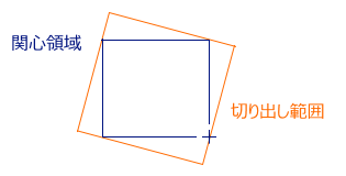
3. Set the region of interest
Specify the rectangle by the Maximum/Minimum latitude and longitude. You can also specify by dragging on the map.
Maximum latitude and longitude
(, )
(, )
Minimum latitude and longitude
(, )
(, )
3. Set the region of interest
Specify the point. You can also specify by dragging on the map.
Longitude and latitude(, )
3. Set the region of interest
Specify the circle by defining the center and radius. You can also specify on the map by dragging from the center point.

Central coordinate (lat and lon)
(, )
(, )
Radius km
3. Set the region of interest
Specify the polygon. Left click on the map to specify the apexes and double click to define.
Specify the coordinate (by Lat 1, Lon 1, Lat 2, Lon 2…)
3. Set the region of interest
Search by all.
3. Set the region of interest
Search the coordinate from the place name. Only registered place names are usable.
List of search result


- Show the list
- Display thumbnail
- My List (login required)
- Save the list (login required)
- Production status (login required)
- alos2 Order
|
Product
Thumbnail
Earth physical quantity
Spacecraft / sensor
Observation starting date and time(UTC)
Observation ended date and time(UTC)
|
No data registered in My List. Batch download and batch processing requests are available for those data registered in My List.
No data registered in the saved list. Those data registered in the saved list of past search results, not search criteria and overwrote the displays of list and thumbnails. Note that the state and information may change according to the product.
The progress showing the status of the batch download and production requests such as cutout processing. Products produced can be downloaded and will be deleted after a certain period.