

First of all, search the data you seek (no registration required)
* Registration required for download.
Search by:


Physical quantities
precipitation, ocean color, etc.
Spacecraft
spacecraft, sensor, level, etc.
Direct download
How to download via SFTP

Login

User registration
Search this site:


Product information / operation
Information about products and their operation is provided by spacecraft.
- General
- GCOM-C
- GCOM-W1
- EarthCARE
- ALOS
- ALOS-2
- CIRC
- ADEOS
- ADEOS-II
- AQUA
- TRMM
- JERS-1
- MOS-1
- MOS-1b
- GPM
- GPM Constellation satellites
- GSMaP
- TRMM(EOC)
- AQUA(CMR)
- TERRA
- SLATS
- GOSAT-GW
Satellite/Sensor/Product Information
For operational information of GCOM-C/SGLI, please refer to the following documents.GCOM-C Observation Plan
Please click here to view the observation plan.(Applicable period : From April 2018 to December 2025)
We prepared some examples of how to read the data.
GCOM-C Orbital Elements
The orbital elements of GCOM-C are listed below in the Two-Line Element(TLE) format.Please refer to this page which includes the file name information.
We update the orbital elements on every Wednesday and Saturday. And the small number is new data.
TLEN_01 TLEN_02 TLEN_03 TLEN_04
TLEN_05 TLEN_06 TLEN_07
*Update
Last 7days
TLEO_01 TLEO_02 TLEO_03
*Update
TLEO_01 (2026.06.10)
TLEO_02 (2026.03.11)
TLEO_03 (2025.12.17)
Product Description
This service calculates and provides the following geophysical parameters from the observation data as standard products.Please also refer to ATBD for product details.
Product Level
Back to top
Geophysical Parameters
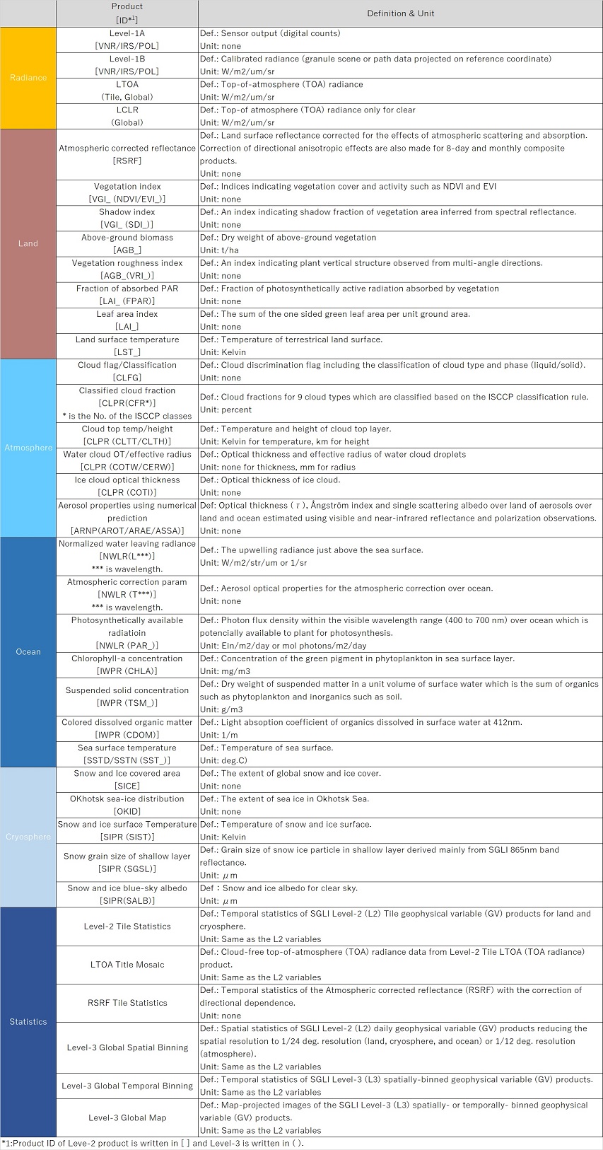
Back to top
SGLI Near-real-time Products
Please refer to About Shikisai Near Realtime Product.Back to top
Granule ID
Please refer to section 4.1.3.3 (L1 product) and 4.1.4.2(L2 & L3 product) of GCOM-C Data Users Handbook to get the Granule ID format information.Back to top
Product Version History
Please refer to the SHIKISAI Portal to view the version history.Back to top
Satellite/Sensor information
For operational information of GCOM-W and AMSR2, please refer to the following PDF.
GCOM-W Orbital Elements
The orbital elements of GCOM-W are listed below in the Two-Line Element(TLE) format.Please refer to this page which includes the file name information.
We update the orbital elements "TLEN" every day. And the small number is new data.
TLEN_01 TLEN_02 TLEN_03 TLEN_04
TLEN_05 TLEN_06 TLEN_07
*Update
Last 7days
TLEO_01 TLEO_02 TLEO_03 TLEO_04
TLEO_05 TLEO_06 TLEO_07
*Update
TLEO_01 (2026.05.05)
TLEO_02 (2026.04.14)
TLEO_03 (2026.02.17)
TLEO_04 (2026.02.10)
TLEO_05 (2025.12.30)
TLEO_06 (2025.11.18)
TLEO_07 (2025.10.14)
Product Description
This service calculates and provides the following geophysical parameters from the observation data as standard products.
Product Level
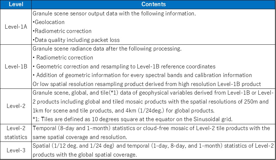
| Product Level |
Contents | Description |
|---|---|---|
| 1A | Uncorrected | The product that contains the count value, variable coefficient for radiometric correction, geometry information corresponding to each observation point (observation position, solar angle, observation direction, etc.), and supplementary information of uncorrected observation data. |
| 1B | Brightness Temperature | The product that contains the converted data from level 1A data, converting observation data into brightness temperature using radiometric correction, and supplementary information same as L1A. |
| 1R | Brightness Temperature (Resampling) |
The product that contains the converted data from level 1B product, adapting the resolution of each frequency and processing altitude correction. |
| 2 | Physical Parameters (Scene) |
The product that contains the converted data from level 1B or 1R product, calculating physical parameters about water (Total Precipitable Water, Cloud Liquid Water, Precipitation, Sea Surface Wind speed, Sea Surface Temperature, Sea Ice Concentration, Snow Depth, Soil Moisture Content), and supplementary information. |
| 3 | Physical Parameters (Global Data) |
The product that contains converted data from level 2 product, including previously defined global grid, observation data of daily or monthly average, and the supplementary information. |
Back to top
Geophysical Parameters
| Area | Physical Parameters | Description |
|---|---|---|
| Atmosphere | Total Precipitable Water | Amount of vertically accumulated water vapor (H2O in gaseous state) in the atmosphere, and defined as amount of water per unit area. Coverage of the product is over the ocean only, and unit is [kg/m2]. Total precipitable water is one of essential hydrological parameters describing state of the atmosphere along with precipitation and cloud liquid water. |
| Cloud Liquid Water | Amount of vertically accumulated cloud droplet in the atmosphere, and defined as amount of water per unit area. Coverage of the product is over the ocean only, and unit is [kg/m2]. Cloud liquid water is one of essential hydrological parameters describing state of the atmosphere along with precipitation and total precipitable water. | |
| Precipitation | Although "precipitation" is usually defined as amount of water, which reaches the surface of the earth from atmosphere as rain and/or snow, microwave imager's precipitation products provide amount of rain (surface rainfall). Coverage of the product is global, and unit is [mm/hr]. Accuracy of rainfall estimate over land, however, tends to be lower than that over the ocean. Method of rainfall estimate used in AMSR2 precipitation product is also applied to "Global Rainfall Watch" system, which distributes global rainfall map in near-real-time. | |
| Ocean | Sea Surface Temperature | Temperature of water at ocean surface. Coverage of the product is over the ocean only, and unit is [゚C]. Its horizontal resolution is about 20-30 km and coarser than that of optical instruments. Microwave radiometer, however, can observe ocean surface through clouds, and monitor continuous change of sea surface temperature over the ocean where few clear region can be found in specific areas or seasons. |
| Sea Surface Wind speed | Wind speed above the ocean surface. Coverage of the product is over the ocean only, and unit is [m/s]. Microwave radiometer can observe wind speed under the clouds, but it is difficult to estimate where there is rainfall and will be missing value. Wind speed around tropical cyclones, however, is important parameter in weather forecast, and we provide research product, which includes wind speed in rainy area over the ocean, as all-weather wind speed research product. | |
| Cryosphere | Sea Ice Concentration | Percentage of sea ice coverage within target ocean area. Coverage of the product is over the ocean around Arctic and Antarctic Sea, and unit is [%]. There is no sea ice within pixel area when sea ice concentration is 0%, and all pixel area is covered by sea ice when it shows 100%. We can learn distribution of sea ice immediately using this product, and it become more and more important because of recent decrease of Arctic sea ice cover. |
| Land Area | Snow Depth | Depth of snow cover over land surface. Coverage of the product is over land only, and unit is [cm]. We do not provide snow cover over the sea ice surface. Snow depth parameter is closely related to climate variation, and this product enables us to figure out changes in distribution of global snow cover. |
| Soil Moisture Content | Amount of soil wetness near the ground surface as volume water content. Coverage of the product is over land only, and unit is [%]. Soil moisture cannot be estimated near the coast, around big lakes and marshes, or areas with wide spread dense forests. Since microwave radiometer can get data constantly and frequently, this product is used in monitoring of large-scale cultivation areas in the continents. |
Back to top
Product Version History
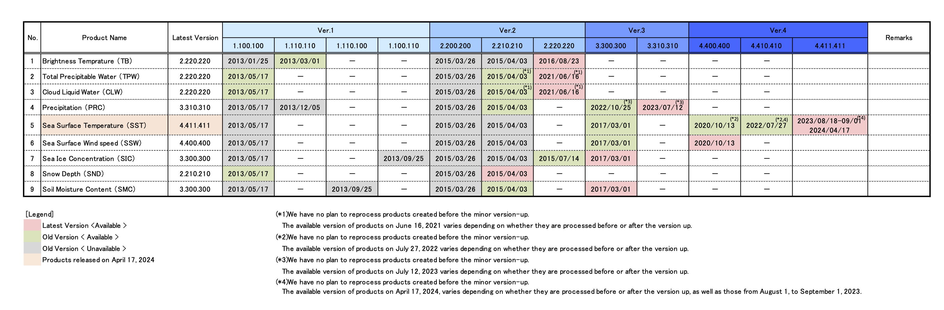
Please refer to here for the details of Ver.2.220.220 of TPW, CLW released on June 16, 2021.
Please refer to here for the details of Ver.4.410.410 of SST released on July 27, 2022.
Please refer to here for the details of Ver.3.300.300 of PRC released on October 25, 2022.
Please refer to here for the details of Ver.3.310.310 of PRC released on July 12, 2023.
Please refer to here for the details of Ver.4.411.411 of SST released on April 17, 2024 for some products.
[ATBD]
https://www.eorc.jaxa.jp/AMSR/datacatalog/index_en.html#reference
Back to top
EarthCRARE/CPR Product information / operation
Information about products and their operation is provided by spacecraft.
For details of the products, please refer to the following project site.
https://www.eorc.jaxa.jp/EARTHCARE/data/prd_list_e.html
https://www.eorc.jaxa.jp/EARTHCARE/data/prd_list_e.html
[NOTICE] Please read the caveats before using product. EarthCARE/CPR data missing list is available from operation status below.
*Please refer to here for past versions of ReleaseNotes.
*Please refer to here for past versions of ReleaseNotes.
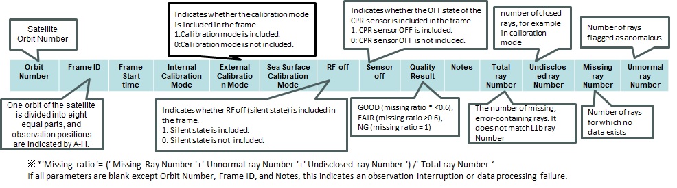
The operational status of EarthCARE/CPR sensors (Orbit Number, Frame ID, Frame Start time, Observation Mode transition history, Missing ray information, etc.) is summarized by year and can be checked from the following file.
[NOTICE] Please open it by a spreadsheet application such as MS EXCEL.
The following is an explanation of how to read operational status in EarthCARE/CPR.
The data provision period of the satellite
There are no operational information about satellite and instruments because this satellite has already finished observation.The data provision period of this satellite is as follows. (search only on G-Portal)
•2006/05/15 - 2011/04/13
ALOS series Open and Free Data
You can get the ALOS/PALSAR(SLC L1.1) and AVNIR-2 products via G-Portal as "ALOS series Open and Free Data."Please check the following site for the details on "Open and Free Data".
https://www.eorc.jaxa.jp/ALOS/en/dataset/alos_open_and_free_e.htm
Additionally, there are no distributors for ALOS/PRISM products.
Information about ALOS-2
For more information, please visit following URLs.•Advance Land Observation Satellite-2 "DAICHI-2" (ALOS-2)
•ALOS Research and Application Project of EORC, JAXA
ALOS series Open and Free Data
You can get the "Open and Free Data" of ALOS-2 via G-Portal.Please check the following site for the details on "Open and Free Data".
https://www.eorc.jaxa.jp/ALOS/en/dataset/alos_open_and_free_e.htm
Other ALOS-2 data can be downloaded only by specific users.
Other users can only search the catalog. Those products are provided for a fee from the following distributors.
[ ALOS-2/PALSAR-2 Product ]
•Remote Sensing Technology Center of Japan
https://www.restec.or.jp/en/solution/product/alos-2.html
•PASCO CORPORATION
https://alos-pasco.com/en/alos-2/
The data provision period of the satellite
There are no operational information about satellite and instruments because this satellite has already finished observation.The data provision period of this satellite is as follows.
•1996/11/01 - 1997/06/29
The data provision period of the satellite
There are no operational information about satellite and instruments because this satellite has already finished observation.The data provision period of this satellite is as follows.
•2003/04/02 - 2003/10/24
Maneuver History
Orbit Control Information (Event List)
Lost Data or Missing Data List
AMSR-E Missing Line Information (Fair Data List)
AMSR-E Data Loss Information (Missing Data List)
Product information
Product Version History
Please refer to here for the details of Ver.8.221.221 of TPW released on Feb 1, 2024.
Please refer to here for the details of Ver.4.401.401 of TB released on June 11, 2024.
Product Information
Please read the caveats in Algorithm and Product Information page before using product.
Maneuver History
Missing Data List
Satellite Information
See Satellite Information other than above.
The data provision period of the satellite
There are no operational information about satellite and instruments because this satellite has already finished observation.The data provision period of this satellite is as follows.
•1992/04/15 - 1998/10/11
The data provision period of the satellite
There are no operational information about satellite and instruments because this satellite has already finished observation.The data provision period of this satellite is as follows.
•1987/02/24 - 1995/11/20
The data provision period of the satellite
There are no operational information about satellite and instruments because this satellite has already finished observation.The data provision period of this satellite is as follows.
•1990/03/09 - 1996/04/19
[NOTICE] Please read the caveats before using product. DPR data missing list is available from operation status below.
Operation Status For 2026
Operation Status For 2025
Operation Status For 2024
Operation Status For 2023
Operation Status For 2022
Operation Status For 2021
Operation Status For 2020
Operation Status For 2019
Operation Status For 2018
Operation Status For 2017
Operation Status For 2016
Operation Status For 2015
Operation Status For 2014
[NOTICE] Please open it by a spreadsheet application such as MS EXCEL.
GPM constellation satellites
Only one satellite for the low-earth-orbit satellite like TRMM lowers the frequency of the observation. In the GPM mission, it cooperates with other satellites to overcome this weak point, and to achieve the frequent observation. The existing satellites carrying microwave imager or the microwave sounder around year 2014 configure GPM constellation satellites. The list of constellation satellites is shown below: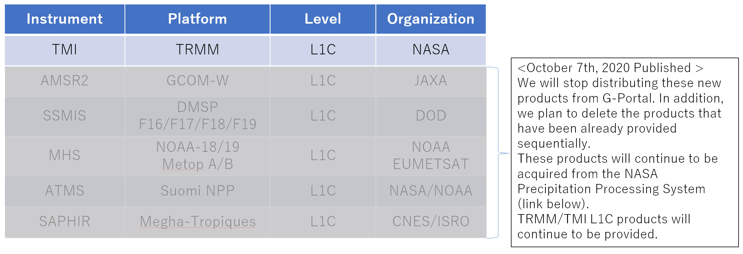
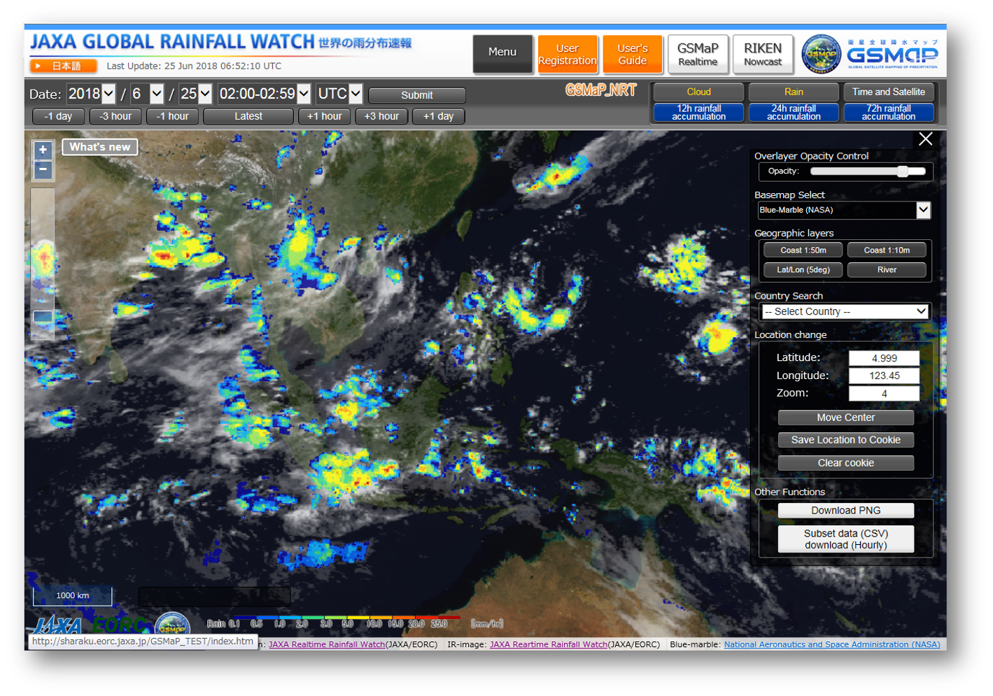
GSMaP Website "JAXA Global rainfall Watch"
The website for monitoring GSMaP.
Product Information
Please read the caveats in Algorithm and Product Information page before using product.
Maneuver History
Missing Data List
Satellite Information
See Satellite Information other than above.
The data provision period of the satellite
There are no operational information about satellite and instruments because this satellite has already finished observation.The data provision period of this satellite is as follows.
2018/02/19 - 2019/10/01
Satellite/Sensor information
For operational information of GOSAT-GW and AMSR3, please refer to the following PDF.
GOSAT-GW Orbital Elements
The orbital elements of GOSAT-GW are listed below in the Two-Line Element(TLE) format.Please refer to this page which includes the file name information.
We update the orbital elements "TLEN" every day. And the small number is new data.
TLEN_01 TLEN_02 TLEN_03 TLEN_04
TLEN_05 TLEN_06 TLEN_07
* Last 7days
TLEO_01 TLEO_02 TLEO_03 TLEO_04
TLEO_05 TLEO_06 TLEO_07
* Last 7 updates (GOSAT-GW conducts autonomous orbit control once every three days.)
Product Description
This service calculates and provides the following geophysical parameters from the observation data as standard products.
Product Level
| Product Level |
Contents | Description |
|---|---|---|
| L1A | Uncorrected | The product that contains the count value, variable coefficient for radiometric correction, geometry information corresponding to each observation point (observation position, solar angle, observation direction, etc.), and supplementary information of uncorrected observation data. |
| L1B | Brightness Temperature | The product that contains the converted data from level 1A data, converting observation data into brightness temperature using radiometric correction, and supplementary information same as L1A. |
| L1R | Brightness Temperature (Resampling) |
The product that contains the converted data from level 1B product, adapting the resolution of each frequency. |
| L2 | Physical Parameters (Scene) |
The product that contains the converted data from level 1B or 1R product, calculating physical parameters about water (Total Precipitable Water, Cloud Liquid Water, Precipitation, Sea Surface Wind speed, Sea Surface Temperature, Sea Ice Concentration, Snow Depth, Soil Moisture Content), and supplementary information. |
| L3 | Physical Parameters (Global Data) |
The product that contains converted data from Level 1B or Level 2 products, generated by applying predefined gridding and temporal statistical processing, and mapped onto global, Northern Hemisphere, or Southern Hemisphere maps. Two types are available: daily and monthly. |
Back to top
Geophysical Parameters
| Area | Physical Parameters | Description |
|---|---|---|
| Atmosphere | Total Precipitable Water | Amount of vertically accumulated water vapor (H2O in gaseous state) in the atmosphere, and defined as amount of water per unit area. There are two types: total precipitable water for ocean areas and land areas, and unit is [kg/m2]. Total precipitable water is one of essential hydrological parameters describing state of the atmosphere along with precipitation and cloud liquid water. |
| Cloud Liquid Water | Amount of vertically accumulated cloud droplet in the atmosphere, and defined as amount of water per unit area. Coverage of the product is over the ocean only, and unit is [kg/m2]. Cloud liquid water is one of essential hydrological parameters describing state of the atmosphere along with precipitation and total precipitable water. | |
| Precipitation | Although "precipitation" is usually defined as amount of water, which reaches the surface of the earth from atmosphere as rain and/or snow, microwave imager's precipitation products provide amount of atmospheric rain and snow. Coverage of the product is global, and unit is [mm/h]. Accuracy of precipitation estimate over land, however, tends to be lower than that over the ocean. Method of rainfall estimate used in AMSR3 precipitation product is also applied to "Global Rainfall Watch" system, which distributes global rainfall map in near-real-time. | |
| Ocean | Sea Surface Temperature | Temperature of water at ocean surface. Coverage of the product is over the ocean only, and unit is [℃]. Its horizontal resolution is coarser than that of optical instruments. Microwave radiometer, however, can observe ocean surface through clouds, and monitor continuous change of sea surface temperature over the ocean where few clear regions can be found in specific areas or seasons. |
| Sea Surface Wind speed | Wind speed above the ocean surface. Coverage of the product is over the ocean only, and unit is [m/s]. Microwave radiometer can observe wind speed under clouds, but it is difficult to estimate where there is heavy rainfall and will be missing values. | |
| All-weather Sea Surface Wind Speed | Wind speed above the ocean surface. Coverage of the product is over the ocean only, and unit is [m/s]. By utilizing low-frequency microwave observations, wind speed can be estimated even in rainy areas where conventional sea surface wind speed products have difficulty estimating wind speed. This enables monitoring of wide-area wind speed, including severe weather conditions. However, spatial resolution and estimation accuracy are lower than those of conventional sea surface wind speed products. | |
| Cryosphere | Sea Ice Concentration | Percentage of sea ice coverage within target ocean area. Coverage of the product is over the ocean around Arctic and Antarctic Sea, and unit is [%]. There is no sea ice within pixel area when sea ice concentration is 0%, and all pixel area is covered by sea ice when it shows 100%. We can learn distribution of sea ice immediately using this product, and it become more and more important because of recent decrease of Arctic sea ice cover. |
| High-resolution Sea Ice Concentration | Percentage of sea ice coverage similar to sea ice concentration. By utilizing brightness temperature at 89 GHz, spatial resolution is improved, enabling more detailed observation of sea ice distribution. On the other hand, it is sensitive to the effects of clouds and precipitation, and it becomes difficult to distinguish between sea ice and clouds under non-clear conditions, resulting in lower estimation accuracy. | |
| Sea Ice Motion Vector | Sea ice motion vector provides the direction and speed of sea ice movement, and zonal and meridional (longitude and latitude) components (cm/s). Coverage of the product is over Arctic and Antarctic regions. This product enables monitoring of sea ice movement and drift, and is used for safe ship navigation, route planning, sea ice prediction, and meteorological and oceanographic monitoring in polar regions. | |
| Land Area | Snow Depth | Depth of snow cover over land surface. Coverage of the product is over land only, and unit is [cm]. We do not provide snow cover over the sea ice surface. Snow depth parameter is closely related to climate variation, and this product enables us to figure out changes in distribution of global snow cover. |
| Soil Moisture Content | Amount of soil wetness near the ground surface as volume water content. Coverage of the product is over land only, and unit is [%]. Soil moisture cannot be estimated near the coast, around big lakes and marshes, or areas with wide spread dense forests. Since microwave radiometer can get data constantly and frequently, this product is used in monitoring of large-scale cultivation areas in the continents. |
Back to top
Product Version History
|
Latest Version |
|
Old Version |
|
Old Version |
[ATBD]
https://www.eorc.jaxa.jp/AMSR/datacatalog/index_en.html#reference
Back to top
(1) Product information / operation
G-Portal provides product information and operational information for spacecrafts and sensors as shown in below.
This information is provided by spacecrafts and sensors, respectively. Please check the detailed information by opening a spacecraft tab you have interested in.
(2) Quotation of DOI (Digital Object Identifier)
JAXA has assigned the DOI numbers to standard products provided at G-Portal since FY2022. (Except for part of products including near real-time products) If you use the product for your report or academic journal etc., please quote the DOI number of such product in accordance with the following webpage.
https://earth.jaxa.jp/doi/
G-Portal provides product information and operational information for spacecrafts and sensors as shown in below.
| Maneuver History | These are the history of controlling the satellite, delta V maneuver which are increased or decreased speed of spacecraft, the yaw-around maneuver which are rotated 180 degrees for keeping the Sun off the +Y side of spacecraft, and so on. |
|---|---|
| Orbital Elements | This orbital information indicates spacecraft position with 6 orbit elements. (Ex; Two-Line-Elements) |
| Lost Data or Missing Data List | These lists are the failure of getting data, lost data or missing data due to fail by some reason, for example, spacecraft orbit control, sensor calibration and so on. |
| Operation Mode history | These indicates the status change of each Spacecraft Operational Mode.(Ex; Observation,Stand-by, Calibration, Memory dump, and so on). |
This information is provided by spacecrafts and sensors, respectively. Please check the detailed information by opening a spacecraft tab you have interested in.
(2) Quotation of DOI (Digital Object Identifier)
JAXA has assigned the DOI numbers to standard products provided at G-Portal since FY2022. (Except for part of products including near real-time products) If you use the product for your report or academic journal etc., please quote the DOI number of such product in accordance with the following webpage.
https://earth.jaxa.jp/doi/