

First of all, search the data you seek (no registration required)
* Registration required for download.
Search by:


Physical quantities
precipitation, ocean color, etc.
Spacecraft
spacecraft, sensor, level, etc.
Direct download
How to download via SFTP

Login

User registration
Search this site:


Tools / Documents
Tools for using satellite products and documents related to product format and other information are available.
- General
- GCOM-C
- GCOM-W1
- EarthCARE
- ALOS
- ALOS-2
- CIRC
- ADEOS
- ADEOS-II
- AQUA
- TRMM
- JERS-1
- MOS-1
- MOS-1b
- GPM
- GPM Constellation satellites
- GSMaP
- TRMM(EOC)
- AQUA(CMR)
- TERRA
- SLATS
- GOSAT-GW
Toolkit
The Tools to use SGLI products are available.
Tools for GCOM-C/SGLI
Operating environment : Windows 10, Linux 2.6(64bit)
The tool is used to convert the imageries in HDF5 files of SGLI products into the generic GeoTIFF files through map projections of geodetic latitude/longitude or polar stereographic coordinates.
The user interface is command line input using CUI (Character User Interface).
For GUI (Graphical User Interface) tools, please use this "Format Conversion Tool".
For more information, please refer to the following manual.
-SGLI Map projection & GeoTIFF conversion Tool User's Manual
Operating environment : Windows 10, Linux 2.6(64bit)
This tool detects the number of RSP-path for raster data in the L2-tiles on a daily basis (01D) based on the observing time and attaches it to the original filename. If the tile includes multiple RSP paths, the tool separates the tile for each of the paths and outputs their corresponding multiple HDF5 files.
The user interface is command line input using CUI (Character User Interface).
For more information, please refer to the following manual.
-SGLI RSP Path Detection in L2 Tile Tool User's Manual
Related Documents and Guidance
Please refer to the following documents.- GCOM-C Data Users Handbook : The utilization of GCOM-C/SGLI products (Update on 2018.12.14)
- SGLI Level 1 Product Format Specification : Specification and format of SGLI L1 product
(Update on 2021.12.27)
- SGLI Higher Level Product Format Specification : Specification and format of SGLI higher level product (Update on 2021.12.27)
Tool
Tools for AMSR2
GCOM-W1 User ToolDownload
platform:Windows 7 (32bit), Windows10 (32bit)
GCOM-W1 User Tool provides users with various functions to use earth observation data of GCOM-W1/AMSR2,ADEOS-II/AMSR and Aqua/AMSR-E. You can display, edit, clip and project them on a map.
For more information, look at the User's Manual.
GCOM-W1 User Tool provides users with various functions to use earth observation data of GCOM-W1/AMSR2,ADEOS-II/AMSR and Aqua/AMSR-E. You can display, edit, clip and project them on a map.
For more information, look at the User's Manual.
platform:Sun, SGI, Linux
There are two ways to read AMSR2 data constructed as an HDF5 file.
One is to use only the HDF5 library, and the other is to use the AMSR2 Product I/O Toolkit which uses
the HDF5 library as internal routine, for reading AMSR2 data in your own C program or Fortran program.
It is necessary to download Leap seconds data with this software.
For more information, look at the User's Manual.
Please be sure to use the old AMTK (Ver. 1.12) for old PRC product (Ver. 1.0).
Related Documents and Guidance
| Documents | Contents | Update Date | Download |
|---|---|---|---|
| GCOM-W1 "Shizuku" Data Users Handbook | Here describes the information and the utilization of AMSR2 products. | 2013/01/24 | |
| AMSR2 Level 1 Product Format Specification | Here describes AMSR2 L1 product format specification. | 2015/03/26 | |
| AMSR2 Higher Level Product Format Specification | Here describes AMSR2 higher level product format specification. | 2022/07/27 | |
| Implementation Guideline for GCOM-W1 Data Provision | Here describes Implementation Guideline for GCOM-W1 Data Provision. Including the application form for becoming "Special-User". | 2018/03/01 |
For more information about changes of AMSR series, please refer to this page.
EarthCARE analysis tools
The outline features of the software tools to visualize or analyze EarthCARE/CPR data are described, as well as the information to get them.Product analysis tools
Below is a summary of useful software for converting EarthCARE data in HDF format into images.For details on HDF files, please refer to the HDF Group homepage https://www.hdfgroup.org.
This is a tool for viewing data in HDF4 or HDF5 format.
https://www.hdfgroup.org/downloads/hdfview/#download
This is a tool for viewing data in NetCDF or HDF format.
https://www.giss.nasa.gov/tools/panoply/download/
This is a tool for processing data in NetCDF format.
https://imos.org.au/netcdfninja
This is a tool for viewing data in NetCDF format.
https://cirrus.ucsd.edu/ncview/
Download the Tool
Download the Document
Download the Document
Download the Tool
Platform: Windows, Mac OS X, Linux
SeaDAS is developed by NASA, and a comprehensive image analysis package for the processing, display, analysis, and quality control of ocean color data including ADEOS OCTS.
For more information, look at the following URL.
https://seadas.gsfc.nasa.gov/
SeaDAS is developed by NASA, and a comprehensive image analysis package for the processing, display, analysis, and quality control of ocean color data including ADEOS OCTS.
For more information, look at the following URL.
https://seadas.gsfc.nasa.gov/
Download the Tool
Platform:Windows
GCOM-W1 User Tool provides users with various functions to use earth observation data of GCOM-W1/AMSR2, ADEOS-II/AMSR and Aqua/AMSR-E. You can display, edit, clip and project them on a map.
Click here for the details
GCOM-W1 User Tool provides users with various functions to use earth observation data of GCOM-W1/AMSR2, ADEOS-II/AMSR and Aqua/AMSR-E. You can display, edit, clip and project them on a map.
Click here for the details
Download the Document
Notification (ADEOS-II)
ADEOS-II Product list
Data Users handbook and Data Format
Product Version History
Earth Observation Data Viewer
AMSR Data Input Toolkit (ADIT)
ADEOS-II Product list
Data Users handbook and Data Format
Product Version History
Earth Observation Data Viewer
AMSR Data Input Toolkit (ADIT)
AMSR/AMSR-E - EORC Bulletin/Technical Report
Download the Tool
Platform:Windows
GCOM-W1 User Tool provides users with various functions to use earth observation data of GCOM-W1/AMSR2, ADEOS-II/AMSR and Aqua/AMSR-E. You can display, edit, clip and project them on a map.
Click here for the details
GCOM-W1 User Tool provides users with various functions to use earth observation data of GCOM-W1/AMSR2, ADEOS-II/AMSR and Aqua/AMSR-E. You can display, edit, clip and project them on a map.
Click here for the details
Download the Document
AMSR-E Data Users Handbook/Format Description
Product & Algorithm
Product version history
Earth Observation Data Viewer
AMSR Data Input Toolkit (ADIT)
Product & Algorithm
Product version history
Earth Observation Data Viewer
AMSR Data Input Toolkit (ADIT)
AMSR/AMSR-E - EORC Bulletin/Technical Report
Download the Tool
Orbit Viewer THOR is a tool for displaying the standard data products of the Global Precipitation Measurement (GPM) mission and Tropical Rainfall Measuring Mission (TRMM). THOR stands for the Tool for High-resolution Observation Review. THOR displays GPM and TRMM products on a map of the Earth when possible, and otherwise, as 2D plots or text output. Since 1997, the Precipitation Processing System (PPS) at NASA Goddard has developed and distributed many versions of Orbit Viewer THOR.
Spacecraft/Sensor: GPM, TRMM
Platform: Windows, Mac OS X, Linux
TKIO(Science Algorithm Input/Output Toolkit), this I/O(input and output) toolkit are designed to make it easy for the Algorithm Developer and/or Researcher to access to the product of GPM and TRMM which were developed by NASA/PPS.
Platform: Windows, Mac OS X, Linux
TKIO(Science Algorithm Input/Output Toolkit), this I/O(input and output) toolkit are designed to make it easy for the Algorithm Developer and/or Researcher to access to the product of GPM and TRMM which were developed by NASA/PPS.
Download the Document
Algorithm and Products Information
Reference documents related to algorithm and product format are archived.
•Product format documentation
•Data utilization handbook
•Algorithm theoretical basis document (ATBD)
•Product format documentation
•Data utilization handbook
•Algorithm theoretical basis document (ATBD)
Download the Tool
Platform: Windows
SAR level 2.1, OPS VNIR level2, and OPS SWIR's CEOS format can be converted to GeoTIFF or KMZ format using this tool. For more information,
Click here for the details
SAR level 2.1, OPS VNIR level2, and OPS SWIR's CEOS format can be converted to GeoTIFF or KMZ format using this tool. For more information,
Click here for the details
Download the Document
Download the Document
Download the Tool
Orbit Viewer THOR is a tool for displaying the standard data products of the Global Precipitation Measurement (GPM) mission and Tropical Rainfall Measuring Mission (TRMM). THOR stands for the Tool for High-resolution Observation Review. THOR displays GPM and TRMM products on a map of the Earth when possible, and otherwise, as 2D plots or text output. Since 1997, the Precipitation Processing System (PPS) at NASA Goddard has developed and distributed many versions of Orbit Viewer THOR.
Spacecraft/Sensor: GPM, TRMM
Platform: Windows, Mac OS X, Linux
TKIO(Science Algorithm Input/Output Toolkit), this I/O(input and output) toolkit are designed to make it easy for the Algorithm Developer and/or Researcher to access to the product of GPM and TRMM which were developed by NASA/PPS.
Platform: Windows, Mac OS X, Linux
TKIO(Science Algorithm Input/Output Toolkit), this I/O(input and output) toolkit are designed to make it easy for the Algorithm Developer and/or Researcher to access to the product of GPM and TRMM which were developed by NASA/PPS.
Download the Document
Algorithm and Products Information
Reference documents related to algorithm and product format are archived.
•Product format documentation
•Data utilization handbook
•Algorithm theoretical basis document (ATBD)
•Product format documentation
•Data utilization handbook
•Algorithm theoretical basis document (ATBD)
Download the Tool
Orbit Viewer THOR is a tool for displaying the standard data products of the Global Precipitation Measurement (GPM) mission and Tropical Rainfall Measuring Mission (TRMM). THOR stands for the Tool for High-resolution Observation Review. THOR displays GPM and TRMM products on a map of the Earth when possible, and otherwise, as 2D plots or text output. Since 1997, the Precipitation Processing System (PPS) at NASA Goddard has developed and distributed many versions of Orbit Viewer THOR.
Orbit Viewer THOR User's Guide
Orbit Viewer THOR User's Guide
Spacecraft/Sensor: GPM, TRMM
Platform: Windows, Mac OS X, Linux
TKIO(Science Algorithm Input/Output Toolkit), this I/O(input and output) toolkit are designed to make it easy for the Algorithm Developer and/or Researcher to access to the product of GPM and TRMM which were developed by NASA/PPS.
Platform: Windows, Mac OS X, Linux
TKIO(Science Algorithm Input/Output Toolkit), this I/O(input and output) toolkit are designed to make it easy for the Algorithm Developer and/or Researcher to access to the product of GPM and TRMM which were developed by NASA/PPS.
Download the Document
Related Links
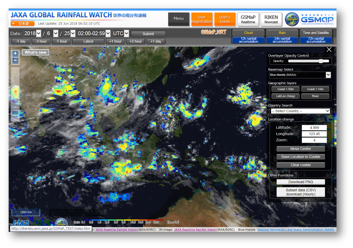
GSMaP website "JAXA Global Rainfall Watch"
The website for monitoring GSMaP.
Download the Tool
Orbit Viewer THOR is a tool for displaying the standard data products of the Global Precipitation Measurement (GPM) mission and Tropical Rainfall Measuring Mission (TRMM). THOR stands for the Tool for High-resolution Observation Review. THOR displays GPM and TRMM products on a map of the Earth when possible, and otherwise, as 2D plots or text output. Since 1997, the Precipitation Processing System (PPS) at NASA Goddard has developed and distributed many versions of Orbit Viewer THOR.
Spacecraft/Sensor: GPM, TRMM
Platform: Windows, Mac OS X, Linux
TKIO(Science Algorithm Input/Output Toolkit), this I/O(input and output) toolkit are designed to make it easy for the Algorithm Developer and/or Researcher to access to the product of GPM and TRMM which were developed by NASA/PPS.
Platform: Windows, Mac OS X, Linux
TKIO(Science Algorithm Input/Output Toolkit), this I/O(input and output) toolkit are designed to make it easy for the Algorithm Developer and/or Researcher to access to the product of GPM and TRMM which were developed by NASA/PPS.
Download the Document
Algorithm and Products Information
Reference documents related to algorithm and product format are archived.
•Product format documentation
•Data utilization handbook
•Algorithm theoretical basis document (ATBD)
•Product format documentation
•Data utilization handbook
•Algorithm theoretical basis document (ATBD)
Download the Document
How to useSHIROP data format specification
Information about SLATS
For more information, please visit following URL.About Super Low Altitude Test Satellite "TSUBAME" (SLATS)
Tool
Tools for AMSR3
AMSR3 Data Viewer (in preparation)
platform: Windows (64bit), macOS (64bit), Linux (64bit)
The AMSR3 Data Viewer is a tool for displaying AMSR3 observation data mapped onto a geographic map.
For more information, look at the User's Manual.
The AMSR3 Data Viewer is a tool for displaying AMSR3 observation data mapped onto a geographic map.
For more information, look at the User's Manual.
AMSR3 Product Attribute Reading Tool (in preparation)
platform: Windows (64bit), macOS (64bit), Linux (64bit)
The AMSR3 Product Attribute Reading Tool is a tool for reading global attributes and dataset attributes of AMSR3 products in Fortran77 and Fortran90.
For more information, look at the User's Manual.
The AMSR3 Product Attribute Reading Tool is a tool for reading global attributes and dataset attributes of AMSR3 products in Fortran77 and Fortran90.
For more information, look at the User's Manual.
Related Documents and Guidance
| Documents | Contents | Update Date | Download |
|---|---|---|---|
| AMSR3 Data Users Handbook | Here describes the information and the utilization of AMSR3 products. | in preparation | - |
| AMSR3 Level1 Product Format Specification | Here describes AMSR3 L1 product format specification. | in preparation | - |
| AMSR3 Level2 Product Format Specification | Here describes AMSR3 L2 product format specification. | in preparation | - |
| AMSR3 Level3 Product Format Specification | Here describes AMSR3 L3 product format specification. | in preparation | - |
| Implementation Guideline for AMSR3 Data Provision | Here describes Implementation Guideline for AMSR3 Data Provision. | 2026/06 | |
| AMSR3 Special User Application Form | Application form for AMSR3 special users. | 2026/06 |
G-Portal User's Manual
G-Portal User's ManualYou can download the manual of G-Portal here.
Earth Observation Data Conversion Tool
Earth Observation Data Conversion ToolSpacecraft/Sensor(Products): GCOM-C, GPM/DPR, GSMaP, GCOM-W, JASMES
Platform: Windows
HDF5/HDF4/Binary format can be converted to GeoTIFF, NetCDF, KMZ format using this tool.
For more information, please refer to the following manual.
Format Conversion Tool Operation Manual for Users
Appendix A Conversion target products
Appendix B Colorbar specification
There is GCOM-C tool for convert to GeoTIFF by command line.
- CUI version tool: detail is here
Download the Tool
Spacecraft/Sensor: Not Evaluated
Platform: Windows, Mac, Linux, Solaris
HDF5/HDF4 format data can be read. For more information, please refer to the following document.
HDF View User's Guide
Platform: Windows, Mac, Linux, Solaris
HDF5/HDF4 format data can be read. For more information, please refer to the following document.
HDF View User's Guide
Spacecraft/Sensor: Not Evaluated
Platform: Windows, Mac, Linux
GeoTIFF format data can be read. For more information, please refer to the following document.
Quantum GIS User's Guide
Platform: Windows, Mac, Linux
GeoTIFF format data can be read. For more information, please refer to the following document.
Quantum GIS User's Guide
Spacecraft/Sensor: Not Evaluated
Platform: Windows, Mac, Linux
NetCDF and HDF data can be browsed. For more information, please refer to the following URL.
http://www.giss.nasa.gov/tools/panoply/help/
Platform: Windows, Mac, Linux
NetCDF and HDF data can be browsed. For more information, please refer to the following URL.
http://www.giss.nasa.gov/tools/panoply/help/
Link
Japan Aerospace Exploration Agency (JAXA)
Overview of JAXA Earth Observation Satellites
Details of JAXA Earth Observation Satellite
Earth Observation Research Center (EORC)
Details of JAXA Earth Observation Satellite
Earth Observation Research Center (EORC)
Other organization