

First of all, search the data you seek (no registration required)
* Registration required for download.
Search by:


Physical quantities
precipitation, ocean color, etc.


Spacecraft
spacecraft, sensor, level, etc.


Direct download
How to download via FTP, etc.


Login

User registration

Search this site:


The contribution of JAXA satellite to GEOSS
October 22 2018 Publish in

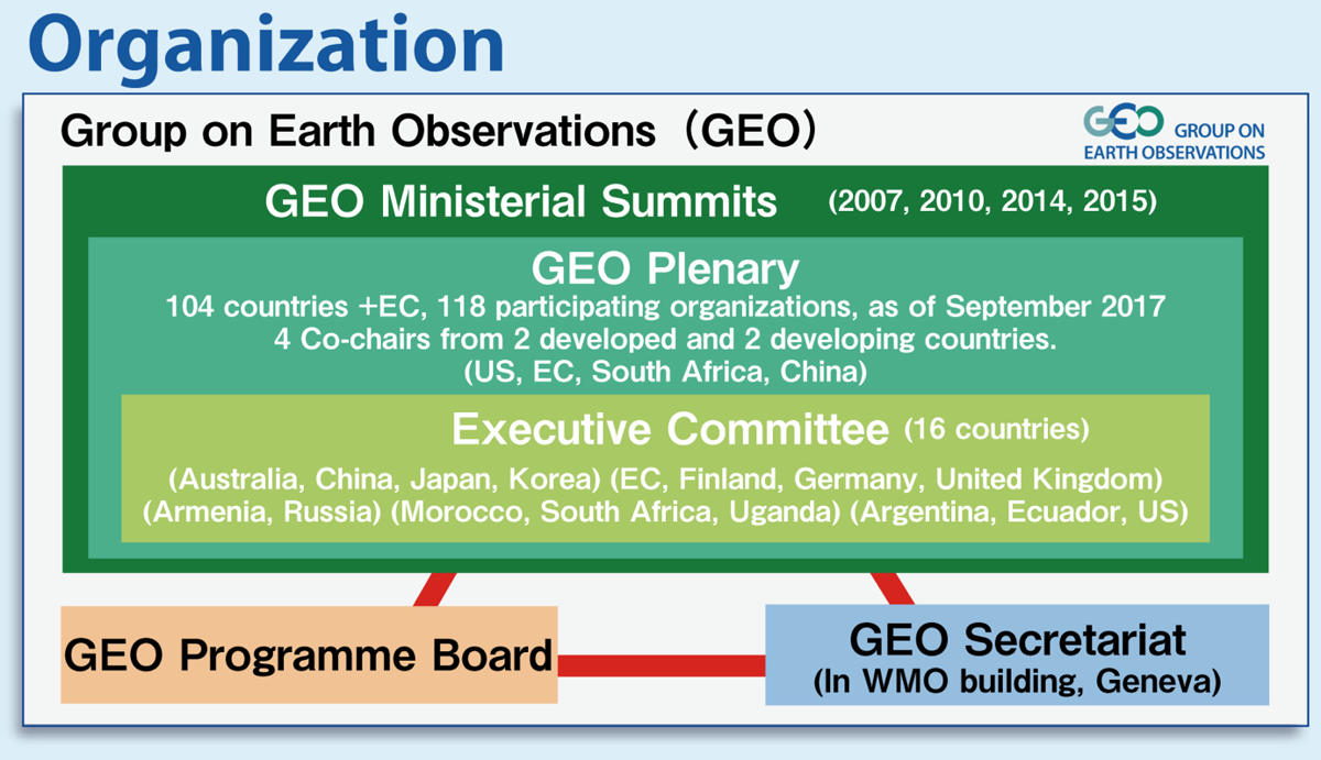
GEO-XV Plenary will be held at Kyoto from Oct.29 to Nov.2. Group on Earth Observations (GEO) is an intergovernmental organization which currently consists of 104 countries + EC and 118 Participating Organizations. The GEO’s vision is to gather the earth observation data of each countries and agencies, and solve the global problems by contributing to Sustainable Development Goals (SDGs) and Paris Agreement. GEO develops and implements a Global Earth Observation System of Systems (GEOSS) and contribute to solve the global problems.

Fig1. The system of Group on Earth Observations (GEO)
https://japangeo.jp/en/staticpages/index.php/about
For example, "Shizuku" (GCOM-W : Global Change Observation Mission Water) greatly contributes to understand the sea-ice extent of Arctic. It is not only expected to solve the environmental problems but also to explore the Northern Sea Route.
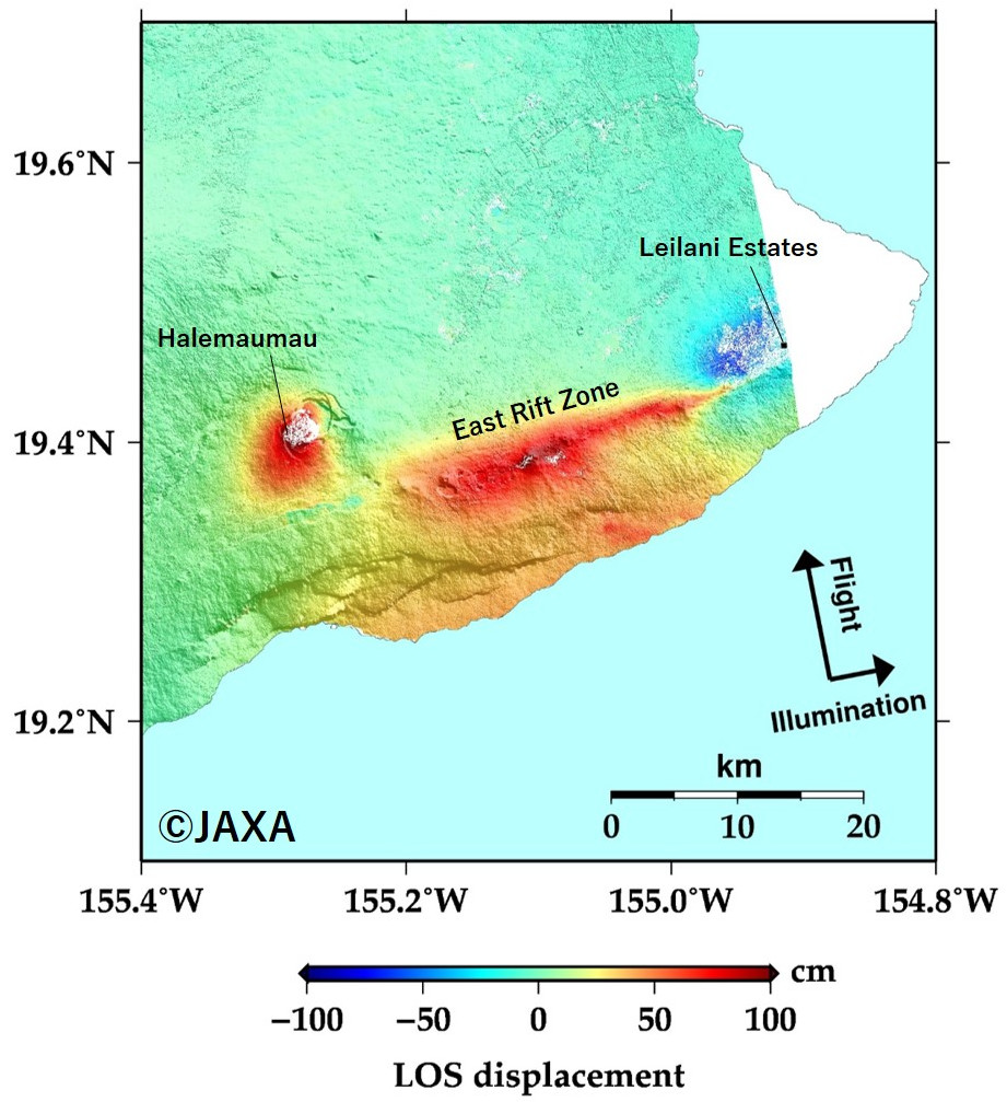
And due to improvement of observation performance and interferometry, "Daichi-2" (Advanced Land Observing Satellite-2) can observe the disaster area with high-resolution and can grasp diastrophism as a plane, and it contributes to prevent and reduce damage of disaster.

Fig 2. Analysis result of flood damage around Okayama on Jul.8 2018
https://www.eorc.jaxa.jp/ALOS-2/img_up/jdis_pal2_heavyrain_westernjapan_20180711.htm

Fig 3. An interferometric image of the ALOS-2 PALSAR-2 data acquired on December 19, 2017 and June 5, 2018.
https://www.eorc.jaxa.jp/ALOS-2/en/img_up/dis_pal2_hawaii_erupt_quake_20180605.htm
JAXA will continue to observe by the earth observation satellite and provide useful data from G-Portal for practical benefit to both local and global society.

Fig1. The system of Group on Earth Observations (GEO)
https://japangeo.jp/en/staticpages/index.php/about
For example, "Shizuku" (GCOM-W : Global Change Observation Mission Water) greatly contributes to understand the sea-ice extent of Arctic. It is not only expected to solve the environmental problems but also to explore the Northern Sea Route.
And due to improvement of observation performance and interferometry, "Daichi-2" (Advanced Land Observing Satellite-2) can observe the disaster area with high-resolution and can grasp diastrophism as a plane, and it contributes to prevent and reduce damage of disaster.

Fig 2. Analysis result of flood damage around Okayama on Jul.8 2018
https://www.eorc.jaxa.jp/ALOS-2/img_up/jdis_pal2_heavyrain_westernjapan_20180711.htm

Fig 3. An interferometric image of the ALOS-2 PALSAR-2 data acquired on December 19, 2017 and June 5, 2018.
https://www.eorc.jaxa.jp/ALOS-2/en/img_up/dis_pal2_hawaii_erupt_quake_20180605.htm
JAXA will continue to observe by the earth observation satellite and provide useful data from G-Portal for practical benefit to both local and global society.
(NOTE) ALOS-2 products are not provided from G-Portal, but can be searched by their catalog information.
 Example of use by years