
November 8 2018 Publish in
 -
- -
-On this time, we introduce the commercial activities which is focused to the beauty of earth observation satellite data.
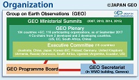
October 22 2018 Publish in
-
-
GEO-XV Plenary will be held at Kyoto from Oct.29 to Nov.2. Group on Earth Observations (GEO) is an intergovernmental organization which currently consists of 104 countries + EC and 118 Participating O
September 27 2018 Publish in
ー
ー
The global climate change is thought to be one of the cause of recent drastic weather phenomenon which seemed on the world.
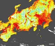
August 30 2018 Publish in
GCOM-C/SGLI
Land Surface Temperature
The
SHIKISAI (Global Change Observation Mission – Climate (GCOM-C)) observed the
extreme heat on Japan.
July 20 2018 Publish in
GCOM-W/AMSR2, GPM/DPR, GSMaP, ADEOS-II/AMSR, AQUA/AMSR-E, JERS-1
-
On
G-Portal, we provide not only product files but also the format
conversion tools as below. It is possible to convert the format which can be read with
generic GIS software.
June 20 2018 Publish in
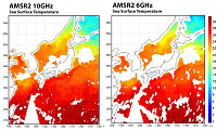
GCOM-W/AMSR2
Sea Surface Temperature
Two types of Sea Surface Temperature (SST) data
observed by AMSR2 on board GCOM-W are provided in the same SST product file as
different layer of each other through the GPortal. One is calculated fr
May 30 2018 Publish in
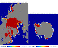
GCOM-W/AMSR2
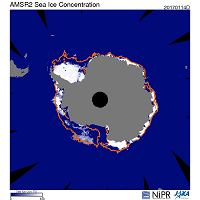
Sea-Ice Extent
The global sea-ice extent hit the lowest
record on Feb. 10, 2018. It was revealed by the observations from the
"Shizuku" (GCOM-W : Global Change Observation Mission Water). The
Global Sea-ice exten
April 26 2018 Publish in
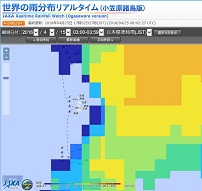
GPM
GSMap
For the “Rainfall in Ogasawara viewing from Space”, a link to the real time Global Satellite Mapping of Precipitation (GSMaP_NOW Ogasawara Islands Version) has been added to the web site of the Og
February 16 2018 Publish in
GCOM-W1/AMSR2
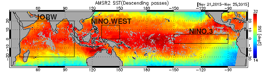
Sea Surface Temperature
The largest El Nino in observation
history (since 1950) occurred in 1997/98, and the magnitude of El Nino in 2015 approached
the same magnitude. According to the Japan Meteorological Agency on N
February 15 2018 Publish in
AMSR2
Sea Ice
Advanced Microwave Scanning Radiometer
2 (AMSR2) loaded on Global Change Observation Mission–Water (GCOM-W) satellite,
“Shizuku,” revealed that the area of global sea ice
reached a "minimum v


 Example of use by years