Typhoons, and hurricanes are bringing huge damage to various parts of the world in this year too. The Tropical Rainfall Measurement Mission satellite (TRMM) had multiple observation sensors, and it was possible to confirm one event from various angles. (TRMM Observation Operation Term: December 1997 ~ April 2015)
Figure 1 and 2 show images of Typhoon No.14 “LEKIMA”, which was located in Vietnam around 12Z (UTC) on October 3, 2007.
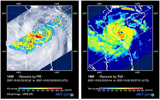
Figure 1 Typhoon No.14 “LEKIMA” around 3Z UTC on Oct.3, 2007
Left: PR precipitation and VIRS cloud image, Right: TMI precipitation
Figure 1 shows typhoon image around 3Z (UTC) on October 2007, 9 hour before landing over Vietnam. Left figure is precipitation measured by Precipitation Radar (PR) overlaying cloud image captured by Visible Infrared Scanner (VIRS), and right figure is precipitation measured by TRMM Microwave Imager (TMI). In area close to the coast of Vietnam on southwest side of the typhoon’s eye, orange-red areas showing strong rain are spreading, which have caused heavy rains on the inland side already. Thus, we can observe the detail structure of rain regardless of land and sea.
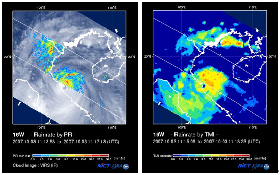
Figure 2 Typhoon No.14 “LEKIMA” around 11Z UTC on Oct.3, 2007
Left: PR precipitation and VIRS cloud image, Right: TMI precipitation
Figure 2 shows typhoon images around 11Z (UTC) on October 2007, 1 hour before landing. Although the observation area of PR covers only the north side of the center of the typhoon in left figure, observation by TMI, the area of typhoon eyes that is the center of the typhoon, exactly on the coast of Vietnam in right figure. TRMM clearly observed the typhoon just before landing.
In this way, the rainfall process in the clouds and the characteristics of rainfall will be revealed by the simultaneous measurement by these three sensors, and which is useful for typhoon evolution and course prediction.
JAXA provides Case Studies using precipitation data obtained by satellites including TRMM/PR and
GPM that is a successor of TRMM, and
GSMaP using multi-satellites data. The case studies were written by actual users in Japan and overseas.
Please see below for more information.

Relevant sites:
TRMM Website
http://www.eorc.jaxa.jp/TRMM/index_e.htm


 Example of use by years